Yesterday, I went out on my second outing with the Chamonix chapter of
the Club Alpin Français (CAF). First a word on this venerable institution: The Chamonix chapter of the CAF was
established in 1902 by MD Michel Payot. Since those days it has seen a handful
of venerable presidents and the current one is Monsieur Roland Ravanel. Roland
was born in 1938 in Chamonix, a man with a passion for the mountain and an avid
skier; he became a ski instructor and mountain guide. He belongs to the prestigious
“Compagnie des Guides de Chamonix” (where he has held leadership positions) and
the ski school of Argentière, his childhood village. He is still skiing and guiding.
As a schoolmaster for over 25 years in Chamonix, he has introduced nearly a
thousand kids to skiing and mountain climbing. On top of all that he is the
nicest guy you’ll ever meet.
The tour took us from Notre Dame de la Gorge (about 3,800 feet) where
the trail head is to Col de la Cicle. It turned up to be pretty long slog as in
miles travelled to Col de la Cicle which is an east facing slope that starts at
about 35 degrees angle. The weather was glorious, the avalanche risk evaluated at
Medium (level 3) but mostly for south facing slopes and we had about a foot of
freshies on a fairly solid snow pack 10 feet deep on top. We had an opportunity
to ski the steeper and longer Col des Chasseurs but some of us (including me)
voted against not wanting to tickle the great white one too much (I was however
a bit jealous and felt some regret when I saw a couple of guys get away with it
a couple of hours later…).
Here are the pictures (click to enlarge):
 |
A bit less than an hour into the hike the ridge line we are looking for appears.
This picture shows from left to right ("Col" stands for pass): Coll du Bonhomme,
Aiguille de la Pennaz and Col des Chasseurs. |
 |
| A view of Col des Chasseurs that gives a sense of how tasty this thing ca be... |
 |
| Col de la Cicle |
 |
| Col de la Cicle: The slope |
 |
| Col de la Cicle: The "backside" with |
 |
| Unlimited possibilities, see the village of Contamines down in the valley where the hike starts. |
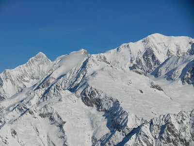
From left to right: Aiguille de Bionnassay 4052 m (13,295), Dome du Miage
3670 m (12,042), and Mont Blanc 4810m (15,783)
 |
| Close up of the Mt Blanc summit |
 |
Close up of the snowfield of the Dome du Miage that under good
conditions is the start of a ski run dropping 9,000 feet... |
 |
| On the way out: Sunset in the mountains... |


No comments:
Post a Comment