Sunday, November 12, 2017

Clomping around Guardsman's Pass - The Return

A few days ago we went out with for our objective the Hidden Canyon Saddle (between Clayton Peak 10,721 and Peak 10,420) on the Guardsman's Pass to Clayton Peak ridgeline. That day we didn’t make it all the way mainly because of our route being just enough off that we missed our objective. So, we went back there today and nailed it!

We started the tour with a skin from Empire Lodge up Orion slope and from there crossed over to Bonanza Flats where the Old State Route 152 and Pine Canyon Rd meet. From there we aimed square for Bloods Lake at about 9,500’. After that, we followed the summer trail towards Lake Lackawaxen and about halfway into the trail we took a hard left (west) towards the headwall under the pass, then skinned it up, et voila!

For the return we contoured, on skins, 10,420’ on the Big Cottonwood side and so skinned through part of Hidden Valley, then onto Sunny Glades and into Promised Land which holds amazing ski lines. Once we made it back to the Guardsman's Pass ridgeline it was skis on the back (not enough snow to ski down) down to Guardsman's Pass. After that, still walking, it was down Old State Route 152. Then it was a skin back up a service road to Deer Valley and down Ontario back to the Empire Lodge.

This does not qualify for a glamorous Wasatch bluebird powder day. However, it’s was still beautiful and it’s always fun to figure out the terrain and approach when you make up your own tour!

Here are the pictures (click to enlarge):
The ridgeline.


Mike, Loki, and Skadi at a frozen Bloods Lake.

On top Peak 10,420 dominating Bloods Lake.

The white field in the center is the slope just under Hidden Valley Pass.

View of upper Big Cottonwood Canyon while contouring the "backside"
of Peak 10,420. In the Center is Mount Wolverine with, to its right,
Mount Millicent, and to its left Mount Tuscarora,

Beyond and above Twin Lakes Pass (center) is
Mount Superior in Little Cottonwood Canyon.

Mike walking down the ridgeline to Guardsman's
Pass. This was a skin up, skin down, climb, hike up
and down with your skis on your back. Anything
but actual skiing! Time for more snow!

Saturday, November 11, 2017

Clomping around Guardsman's Pass - 11-09-2017

We decided that with our really thin snow "cover" we needed to go highish. However, also wanting what could pass for a ski out, we picked the gate where the 224 is closed for the winter. That would be our starting point and how we got back to the car. Other than that the objective would be the Hidden Canyon Saddle between Clayton Peak and Peak 10,420 on the Guardsman's Pass to Clayton Peak ridgeline.

We skinned from the winter road closure gate to Empire Pass and from there on to where the Old State Route 152 and Pine Canyon Rd meet. From that point, we crossed over and into the Bonanza Flats. After that, it was all improvisation.

One thing that surprised us a bit was the one foot plus snow depth on the north facing as we got higher on fairly steep terrain towards the ridgeline. A bigger surprise yet was that the snow audibly settled on that very avalanche-prone terrain. As a consequence, we rerouted towards more benign terrain and made it to the ridgeline which turned out to be an awesome viewpoint for lunch break.

The return started with a walk, skis on the back, on the ridgeline to Guardsman's Pass. After that, we were planning on skiing down Old State Route 152 but the snow was so thin we would have ended up in a protracted stone grinding session of our bases on the pavement. So we walked half of it and glided the rest where the cover was marginally thicker. Then it was a skin back up to Empire Pass and the anticipated "ski out" on the 224 down to the gate.

As you can see this is not your glamorous Wasatch bluebird powder day. was the skiing fun? Nope. Is it fun being out exploring terrain using any excuse to put skis on? You betcha!

Here are a few pictures (click to enlarge):

From Bonanza Flats looking up to Guardsman's Pass

The unnamed peak 10,420. Our initial objective
was the Hidden Canyon Saddle to its left.

Mike breaking trail towards Bloods Lake.

This picture was not taken today but is useful to give a better idea of the
overall lay of the land. The far right of the picture just cuts off Guardsman's
Pass. Going left, the first knob is point 10.200, after that the pointy
on is peak 10,420, then the deep pass is Hidden Canyon
Saddle and then Clayton Peak (center-left of picture) at 10,721'.


Tuesday, October 31, 2017

PCMR is Getting Ready for the 2017/2018 Season

PCMR has already been making snow. Seeing the temperatures in the forecast they do have some reasons to expect it's not all a wasted effort. The pictures below are taken just below the old angle station so at just about 8,000’ or so (click to enlarge):
Skadi LOVES the snow - even the fake kind...

Dashing through the snow...

Loki & Skadi duking it out.

The snow may be fake but the ambiance is grand!

Thursday, October 26, 2017

Snow in the Cottonwoods

Was up on my weekly hike to Jupiter this morning in lower grade stormy weather. Got a peek into Big & Little Cottonwood and the snow is still clinging on to some North and North-East facing slopes. The dogs and I actually got snowed on. It was only flurries but it sure sets the right ambiance.

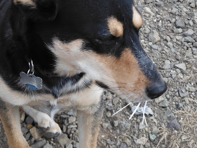
It is confirmed that Loki is still addicted to trouble. Last time it was a solid gash on his left upper leg, this time it involved a porcupine (see the last picture below).


Here are the pictures (click to enlarge):

In the center Mt Wolverine BCC, in the distance to the left Sugarloaf LCC.

What snow flurries over Park City look like from 10,000 feet.

What Loki looks like after a close encounter with a porcupine...

Saturday, October 21, 2017

Mobile Powder Response Unit

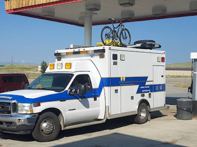
Saw this ambulance repurposed as an RV the other day in Park City. Far and away the coolest snowmobile I’ve ever seen! This guy is winning at life. The back and side say, "Mobile Powder Response Unit". Furthermore, the back has an all capitalized “SNOWEMERGENCY”. The front seems to have a SNOWEMERGENCY in reverse just like the ambulance have an "AMBULANCE" in reverse for the benefit of your rear-view mirror. 

If you, the owner of this awesome vehicle, read this, identify yourself, take credit, and tell us about the inside of the vehicle and your travels! (I greyed out you plates to protect what's left of your privacy...)

Here are the pictures (click to enlarge):

Here is the response unit in all its glory. Seemingly in its summer
config with a mountain bike on top (this picture I found on the Net).

The same vehicle from the back. This is the picture I took from my car
last Thursday on the I80 at the Park City (Kimball Junction) exit.


Monday, October 16, 2017

2nd Ski of the Season

Yesterday it was back to the Timpanogos “glacier” (click here for the last post on this). Several people, seeing my skis on my back on the way down, asked if I had skied the “glacier” so I guess that terminology survives the realities on the ground. At 20 degrees, it was pretty cold when I started at the trailhead at 7am.

Within about 30 min of the start, we got charged by a huge and possessed moose. The hero of the day was Loki (Australian cattle dog) that knew exactly what to do to get that thing off of Skadi’s and my back. This was a cow with her calf and eventually, Loki got them to escape down the valley. I am eternally grateful because, for a while there, I could feel this moose’s breath…
This was animal day and we got to see mountain goat too. They, however, didn’t charge us. Later Skadi had an afternoon snack (see picture below) on a goat.

The skiing was less exciting than a powder day but more fun than church… As seems to always be the case for me at the Timpanogos snowfield, the skiing is average but the experience is semi-epic!

Here are the pictures (click to enlarge):
One of the day's goats. There were quite a
few of them but this one was closest.

Loki on top - Skadi just below.

Nice ice falls add to the wintry feel.

My gear and the dogs at the shelter.

The snowfield held a little less fresh snow than
 two weeks ago but is still looking pretty darn good.

It was cold enough to make it, at least in parts, feel like a glacier.

The higher part of the snowfield.
The saddle is at about 11,300'

On the lower field, you can see my up-track (trampled by the dogs). 

Skadi keeping watch over my skis.

Skadi having her afternoon snack...

Friday, September 29, 2017

First ski of the 17/18 season

Went back to the Timpanogos snowfield and it held quite a bit more snow than a couple of weeks ago. That snowfield is how I get September skiing in in Utah but you gotta want it pretty bad! One, the skiing is good, not great but good. Two, you have to be your own pack mule carrying a bit over 40 lbs for 3,500 feet and some before you start skinning. Then you have to gain another 1,000 feet before you get your first turn in! However, if you’re into that kind of thing, this is the place for you. I was solo so no pictures of me skiing but you do get to see me at the Emerald Lake Shelter (base of the snowfield) with my impossibly heavy pack.

I was planning on a few laps but I only got one run in before Loki (my dog) got hurt with a pretty impressive gash on his left forward leg (see picture below). Now I had to book it down asap to make it to the vet before they close for the day. I had to drop those 3,500 feet and six miles half-running (best I could do) with that heinous load on my back. I made it to the vet in Park City with about 6 min. to spare. Thankfully White Pine Veterinary Clinic puts the dog first so they were willing to do the overtime for Loki.

Here are yesterday's pictures:
Aspen Grove parking lot when I
was still excited about the load.

Hidden Lakes Cirque is now mostly white.

Yours truly not a little self-satisfied and getting that load to the
Emerald Lake shelter. Foto credit: Wade from Mississippi.

The snowfield has improved a lot in the last two weeks...

...especially the higher part to the Saddle.

Loki standing right in the way.
That's before he got hurt (see below).

Although this was my first ski I did not have to break trail.

This is after the first lap. Loki "caught an edge" and
the "rescue mission" was in full swing.


The "before" pictures: Same place - 11 years ago

These pictures are from September 30, 2006, when I went up with my son, Nico (he was just 14 at the time):


Nico ready for a bright and early start!

Pretty good cover in the higher cirque.

Nico and I toiling up the interminable snowfield.
That day was a lot sunnier than yesterday.

Finally on top with a fairly long ski ahead of us...

...and finally the reward!

Sunday, September 17, 2017

The Mt Timpanogos Snowfield is Back!

This used to be presented as a “permanent” snowfield in reaction to more ambitious word choices such as “the Timpanogos glacier” that you can find here and there in the literature (not naming any names here…). That snowfield was proven un-permanent when it vanished some years ago, and up until and including last summer, there wasn’t a flake of snow on that field, only desolate rock.

Having been up that mountain a lot of times, I have noticed, in seasons past, that even one good storm can produce surprising amounts of snow and a reasonably good snow cover. Considering further that last winter produced a copious amount of snow, and it just snowed up there yesterday afternoon and parts of the night, I figured a visual inspection may be in order. Although quite curious, I was not overly optimistic thinking it would take quite a few seasons to rebuild a thing like that. Well, I got to find out that that snowfield is very substantially back! It is close to the shape it was in when I last skied it. One or two more decent seasons and this thing may start feeling a lot more permanent again… While waiting for that, the short term is very encouraging as can be seen in this NOAA forecast for this week at 10,300’ (bottom of the snowfield):
The graphics for this forecast only goes till Thursday night. After that,
the text version says "Chance of snow" from Friday till Sunday included.

The snowfield, when full, starts by the Emerald Lake Shelter at about 10,300’. It is encased by a triangular cirque with the following boundaries: at its west the Mt Timpanogos summit (11,748’), at its east the Mt Timpanogos shoulder (11,161’), and at its southernmost point the saddle where you start skiing (11,300’). The map below shows the Saddle and the Shoulder, materialized by the dashed line is the best ski line i.e. the one with the least double fall line.

…and here are today’s pictures (click to enlarge):
First impressions are everything! This is the view that opens up
about an hour into the hike up.

Same view but including Primrose Cirque which
holds some of its own snowfields.

"The Timp Glacier" in all its splendor and at about 90% of the best
I ever saw it.

Closing in on the upper part of the snowfield. The very top
 is why it's not at 100% as the first 100 or so feet need more snow.

A couple of guys came up from the Timponeke trail with their skis. This one
is booting up with skis on the backpack.

Partial view of Emerald Lake as seen from the shelter.