Friday, September 11, 2015

Where do I get my Dynafit installed?

So you got your skis, you got your Dynafit (or any other tech bindings) and now you need to get them on. I do most of my binding installs myself because there is no part of skiing that I don’t enjoy. Having said that I do make an exception to the DIY thing and that’s Dynafit. Why? Because these are very sophisticated bindings that although they look all puny are more laterally stiff than most resort bindings at a fraction of the weight. This is a precision instrument and I want to make sure that the installation is up to task in order for me to realize all the benefits of being on a pair of Dynafit. To get to that you want a certified Dynafit installer to do the job. Below is a list of expert retailers in our area. There probably are more but I am only listing the ones I have had great experiences with. These retailers of course can offer a lot more than just binding installations.

Locals first - that is if you are from Park City:

White Pine Touring
Cost: $25.00
1790 Bonanza Dr,
Park City, UT 84060  
(435) 649-8710

White Pine will not be ready for this work until the second week of October so you can either wait till then or go down to Salt Lake. Also, the price will need confirmation, George was not exactly sure and told me "between $20 & $25 somewhere".

In Salt Lake City:

REI
Cost: $45.00
Canyon Rim Center
3285 3300 S
Salt Lake City, UT 84109
801 486 2100
$45.00

Wasatch Touring
Cost: $45.00
702 E 100 S,
Salt Lake City, UT 84102

Wasatch Powder House
Cost: $50.00
3138 East 6200
South Holladay, UT 84121
Map

The 9 items you must, at a minimum, have in your BC ski back pack

Other than nutrition and hydration, what are the minimum requirements you should establish for the content of your BC back pack? Below list is not a recommendation for the optimal back pack. These are just the very minimum requirements that no one should ever go out to BC ski without. Because they are all required there is no order of priority, item number nine is just as critical as item number one on the list.

  1. Shovel you also must have a beacon but that one goes on you, not in your pack…
  2. Probe
  3. Rain gear to be used as insulation and/or wind protection as needed
  4. Map and compass, would visibility suddenly vanish, you may need them
  5. Waterproof matches and/or lighter
  6. Flashlight or better yet a headlamp
  7. First aid kit
  8. Emergency shelter, lightweight emergency bivouac sac or space blanket
  9. Cell phone


1. Shovel with telscopic handle, 2. Probe, this one is carbon
and 
so wheighs more or less nothing! 3. Minimalist Marmot
rain jacket, 
4. Map of your area and for compass I use my
altimeter watch, 
5. Matches, 6. Minimalist (and light)
headlamp, 7. Emergency medical kit, 8. Mini bivvy
sac, and 9. Cell phone.
The idea with above list is that you should, with that content and some common/backcountry sense, be able to make it through a night in the BC. But “I am not doing an overnighter” you say. I am just doing day tours. Well, the thing is you never really know that for sure when you leave in the morning. That may be plan A, this is your plan B. Accidents are more likely to happen later in the day when everyone is tired. This being winter and the days being extra short, it significantly increases the chances that, if you are injured, rescue will only get to you the day after.


Now, above and beyond just surviving in the back country, here are a few items that when added will help make the outing actually enjoyable:

  1. Extra pair of gloves
  2. Extra layer of clothing for warmth
  3. Extra trail mix or similarly convenient food
  4. Rub on wax for your skins
  5. Ski crampons
  6. Extra ball cap*
  7. Swiss army knife or multi tool

Both 4 & 5 are mostly for comfort. The rub on wax is not only for spring skiing because 1) any day can get locally hot, and 2) whenever you have to ford a creek your skins can get wet and you will want to wax the snot out of them. For you to really enjoy your ski crampons all it takes are a couple of sunny days followed by a really cold night and your easy traverse will be an ice trap waiting toi see you tumbling down the hill. What I am trying to say is that you may need these things when you least expect them.

*) This one of course depends on if you even use a ball cap in the first place. If you are like me and you use it for the up-track as a combined sun shelter and sweat band, then having a second one for real long days is great as in a dry one for the afternoon. Also, if your first ball cap blows off your head as the ridge winds hit you unexpectedly, then that extra one will be great to have. After losing a few favorite ball caps to these winds I finally got it and get the darn thing off my head before it vanishes down some unattainable cliff band, but it sure took a few losses to get me there.

As important as equipment is in the back country none of it will fulfill its potential unless we are properly and thoroughly trained on how and when to use them.

Sunday, September 6, 2015

Cardiff Fork in March of the worst Wasatch winter on record

These are pictures taken during an outing last March. In a season 2014/2015 that was the worst on record these pictures show that provided you stay high enough, you can get good powder days in the Wasatch in any season. We started our skin up Cardiff from Big Cottonwood Canyon and skinned up towards George’s bowl.

Directions to TH: Follow Big Cottonwood Canyon (SR 190) about 8.8 miles up the canyon to Cardiff Fork aka Mill D South Fork on the USGS map. In winter use the parking lot by the 190. In summer you can drive a bit further (1 1/4 miles) up Cardiff Fork to the parking areas by the campgrounds.

Here are the pictures (click to enlarge).


Powder below Geroge's bowl.

...and some more powder...

Mike summited!

Did I mention there was a fair amount of snow?

View of Hallway couloir leading in to the Tube.

Holy Toledo!

Sunday, August 30, 2015

Recon mission: Deseret Peak in the Stansbury Range

Between the Wasatch Range (a western range of the Rocky Mountains in Utah) and the Sierra Nevada (mostly in California) there is the Basin and Range Province (some will argue that that’s what the Wasatch is in). The Basin and Range Province is a vast physiographic region that spans 500 miles from the Wasatch and the Colorado Plateau to the Rio Grande Rift. A peculiarity of this region are the abrupt changes in elevation, alternating between narrow faulted mountain chains (all in a North to South alignment) and desert flats. Edward Dutton, who was a US Geologist in the 19th century, described these as “an army of caterpillars marching toward Mexico". Some of these “caterpillars" are (from East to West):

Oquirrh Mountains, UT, highest elev. 10,620 Flat Top Mountain
Stansbury Range, UT, highest elev. 11,031 Deseret Peak
Snake Range, NV, highest elev. 13,063 Wheeler Peak
Schell Creek Range, NV, highest elev. 11,883 North Shell Peak
Ruby Mountains, NV, highest elev. 11,387 Ruby Dome

There are many more but this is not where I’ll expound on that. The object of yesterday’s hike was Deseret Peak in the Stansbury and the reconnaissance was for ski lines in preparation for a rturn this winter. We were in particular looking for three specific couloirs and a sense of the lay of the land in general. We got a good sense of both. 

The hike

The summer hike is best done through Mill Fork. Past the TH walk past the Wilderness sign, cross the creek (that may be dry) shortly after which you'll be at a trail intersetion. You will Pick Mill Fork to the left. You'll be doing about a mile, maybe a bit less, in the forest before you reach a large meadow. You will cross it and it will take you to a saddle at 10,042 feet. There you'll be at a t in the trail with left being Bear Fork and right being Deseret Peak. Follow the trail to the summit. For the return you can of course just go back the way you came or loop it via Pockets Fork. This second alternative is a bit longer than the out and back alternative.

The whole hike (done as a loop) is about 8.4 miles and a bit over 4,300" elevation gain in all.

NOTE: There is some confusion online and I believe on the ground on some of the signs at the mountain in the naming of South Willow Fork and Dry Lake Fork. In all my posts, when marked, I always go by the USGS names. In this case the USGS name for the fork that constitutes the basin at the north of the peak is Dry Lake Fork.

Ski lines

The couloirs we were looking for are the East Twins and the North couloirs (see below). In terms of what skiers look for these couloirs are not named right. The Esat Twins are north facing and the "North" couloir is Esat facing. These distinctions will matter when time comes to assess snow quality expectations. We noticed quite the uptic in winds around the entrances of these couloirs and since there is no reason that will change in winter, there is a good chance the entrances wil be pretty windloaded.

Our winter ski route up will most probably (depending on conditions) be up Dry Lake Fork and a bootpack up the couloirs. Again, depending on conditions, either Dry Lake Fork or Mill Fork can be good candidates for the ski out.

Driving directions to the trail head (from Salt Lake City)
  • Follow I-80 to (exit 99) named for Tooele/Stansbury
  • Go south on Highway 36 for 3.5 miles
  • Take a right on State Road 138 and follow for 11 miles to Grantsville
  • Take a left on West Street at the end of town, this road will become Mormon Trail Road
  • Drive 5 miles south from Grantsville to a sign for South Willow Canyon (careful here: About two  miles before this sign, there is a sign for North Willow Canyon and I learned the hard way that when it comes to directions 2 out of three correct ain’t good enough…)
  • Take a right and follow this road which becomes gravel near the national forest boundary
  • Go to the end of the road at the Loop Campground and trailhead

The Loop Campground is the one at the trailhead. If you decide to camp it’s a good alternative as you can wake up and start hiking right from it. If however you are pickier and want your campsite on the creek then you’ll have to pick one of the lower ones such as Narrows.

In terms of facilities the Loop campground has a vault toilet and that’s about it but it’s very pleasant. In 2015 the fee is $14/night for a site and one car. You pay cash or by check using envelopes available at the entrance of the camp.

Here are the pictures (click to enlarge):

The trail head at Loop Camground

This is where you get off your ATV...

Getting out of the woods...

...and into the Mill Fork meadow.

You are out of Mill Fork, you are at 10,042" and you are taking a sharp right...

...up this trail. You have just another 1,000 feet of elevation to go.

At about 10,400" looking South

Our group on the move and closing in on the summit.

Looking down the Eastern most of the twin couloirs.
This is the narrower one of the two.

Looking down the Western most of the twin couloirs. This is one is
wider and both drop you down into Dry Lake Fork .

The entrance to the Northern couloir.

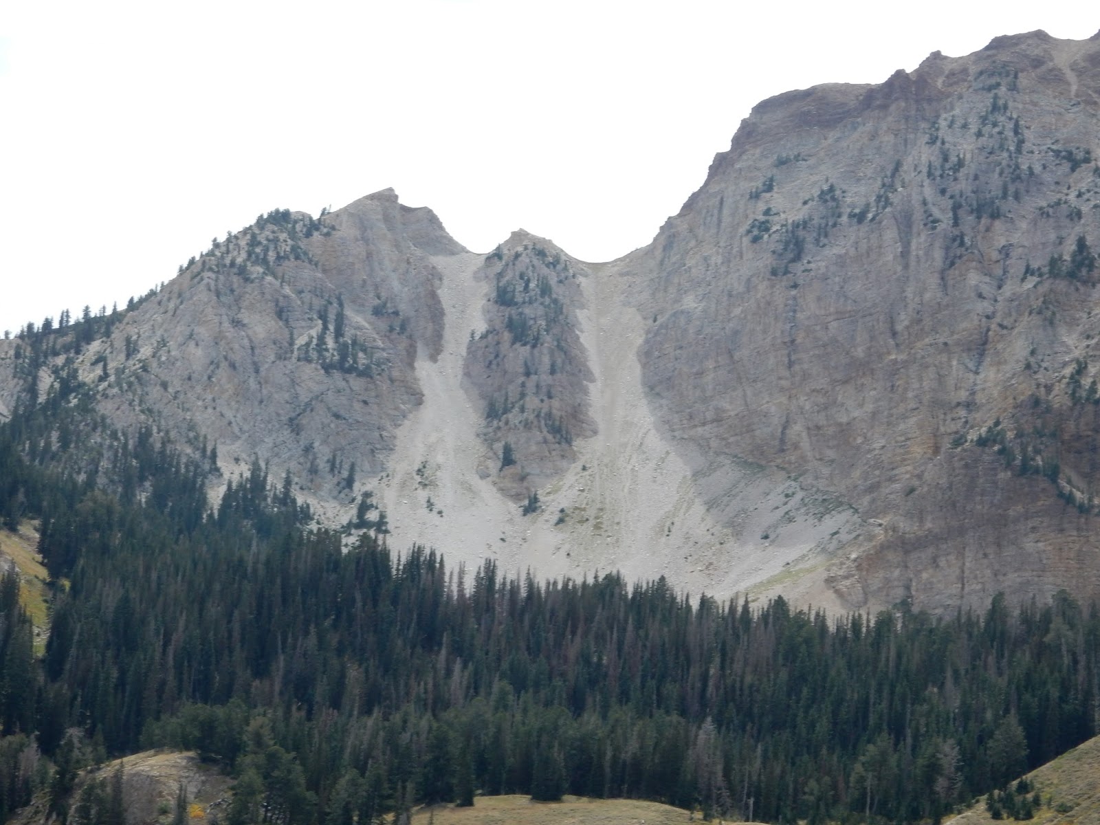
1) Eastern most twin, 2) Western most twin, 3) North couloir

Close-up of the twins.

The Northern couloir as seen from Pockets Fork.

1) Approximate location of the TH, 2) Dry Lake Fork, 3) Mill Fork.

Thursday, August 27, 2015

What AT Ski Boot width is right for you?

Maybe because I have fairly wide feet, the one thing that over the years always defined and still defines my choice of AT boot is its width (another criteria is number of buckles, mine are always four buckle boots). Most AT ski boot makers use just the one mold for their AT boots. The one thing you can’t have is boots too narrow for your foot, that’s the best and fastest way to turn a glorious backcountry day into a miserable Guantanamo type experience. Of course you still have to get your size right and for that you’ll need to figure out your mondo size.
The thing I used to struggle with was:

1) How to figure out what width my foot is
2) How to figure out what width the boots are

Came to find out that figuring out the width of my foot is actually simple as 1-2-3: It is the width of your foot at its widest. The experts talk about “metatarsal” width.  To measure it I put down my foot, on a piece of cardboard, parallel to the wall with the outside to the wall and on the inside find the part that protrudes the most and make a notch there, then measure that width.

So what is considered wide vs narrow? As an example, if you are a US men’s size 10, then a foot width of about 3.8" (96.5mm) is considered narrow, 4.0" (100mm) is considered pretty standard and 4.2" (106.6mm) is considered wide. For width on all other US men’s sizes see this table:

When it comes to the “metatarsal width” of your boots, the experts talk about “Last width”. That is the widest they are on the inside. These days that measurement is a lot easier to find than just a few years ago. As an example www.backcountry.com now lists it as one of its measurements under “Specs”. Once you have a length, a width, then I recommend you take a look at an Intuition liner to improve your fit. Another tool in the bag is the ability to punch out a boot shell. If the boot width is almost there but just tight enough to develop an unbearble pressure point over a few hours of touring, then have them punched out. Any full service sports store in Park City knows how to do that.

Below are a few boots I like from widest to narrowest. Brand, Model, and last width are indicated in the captions. The width you’ll see below is pretty typical of the width of the whole brand at least as far as their AT boots are concerned (click to enlarge):
Scott Cosmos (previously Garmont): 103.5mm - 4.07"

Black Diamond Quadrant: 103mm - 4.05"

La Sportiva Spitfire 102mm - 4"

Scarpa Maestrale: 101mm - 3.95"

Dynafit TLT6: 99mm - 3.9"

Sunday, August 23, 2015

Curiosa at Park City Mountain Resort

This is another one of uncountable hike-to-ski outings to Jupiter Peak. Having nothing better to do, while awaiting the season, I took below pictures. As you can see killing some more summertime while waiting for better is the main reason anyone would bother to take them. Now, if you are reading this then I am pretty sure you are facing the same challenges (click to enlarge).

This odd looking thing has caught my eyes more
 than once and I am sure anyone else's that's been here...

...well, after thorough investgation: Mystery solved!
I am sure you are all excited with this invaluable tidbit!

Here are some remains of the actual Silver King Mine (by the base
of the Bonanza lift).

A Vail resort innovation: All lift stations are now red and grey vs. just
white before. It looks fine but I kinda liked the all white that gave them
a bit of Station Zebra look. 

I have decided to name this one: HOPE

Not really sure as to what the theme may be here. Angry,
mutated pacman-frog? Or maybe just another
disentchanted Trump voter...

I am starting a series on mountain colors, I think I'll call this one Blue...

...and this one Yellow. I promise to stop as soon as we have it all white...

Sunday, August 2, 2015

Cardiff Fork – What’s under the snow?

For those of you who have never seen what’s under the snowpack, here are a few pictures of the same features/slopes taken in winter and in the summer. The shots are not all taken from rigorously the same angle but you will still be able to figure out what is what. As can be seen, other than the Ivory slabs, it’s mostly grass on the slopes proper and rock above. Here are the pictures (click to enlarge):

Cardiac bowl winter

Cardiac bowl summer. The angle is not the same but you can 
clearly see what the snowpack rests on.

Cardiac bowl winter

Cardiac bowl summer

Hallway Couloir winter

hallway Couloir summer

Holy Toledo winter

Holy Toledo summer